Sma’ Glen: liminal landscape

Many years ago, as I was buying my first ever house in Perth, I remember the solicitor advocating the Sma’ Glen as a landscape to explore and photograph. He wasn’t wrong, but it’s taken over a decade to really start to explore it properly.

First there’s the natural appreciation of the place – light and landscape.

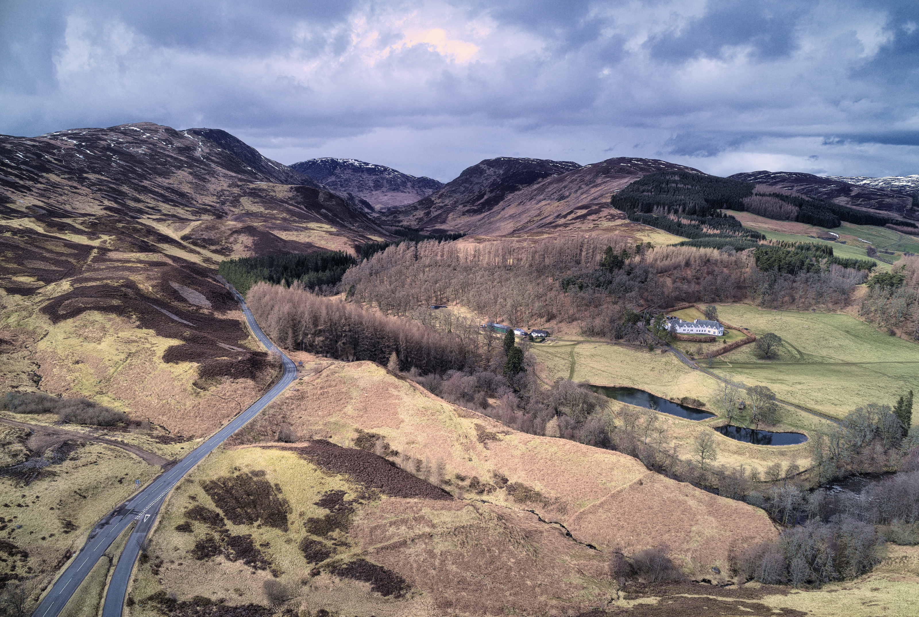
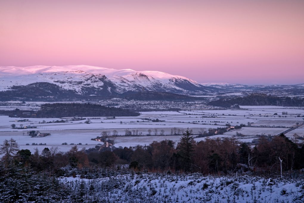
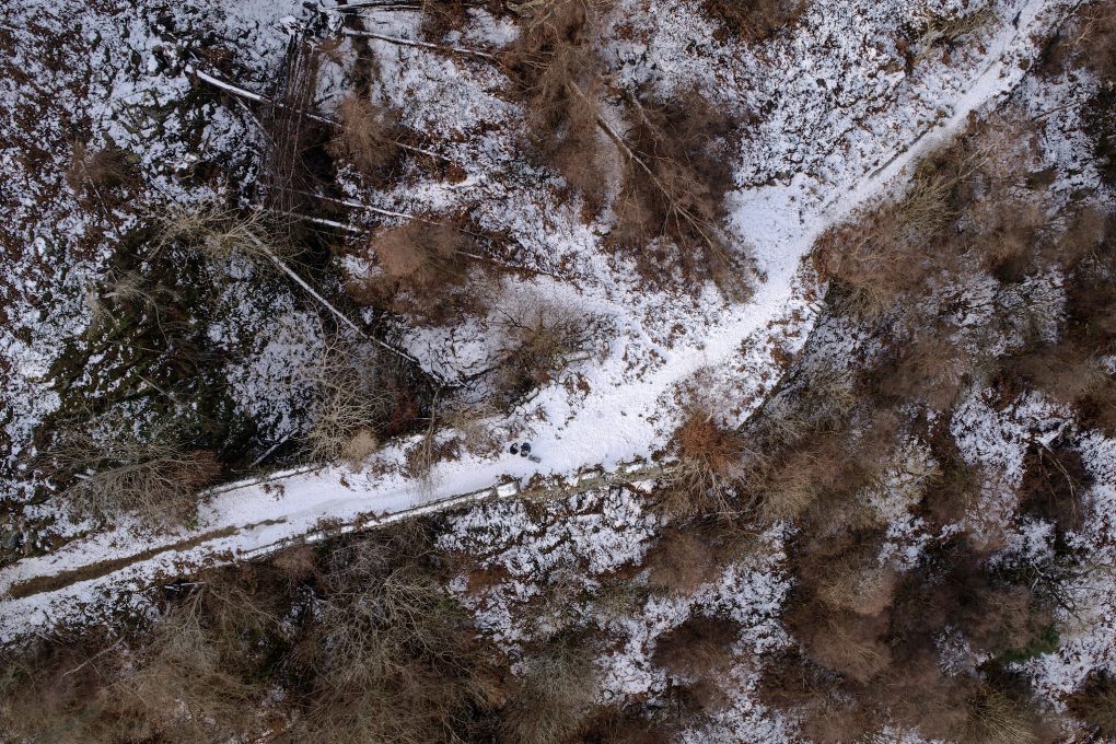
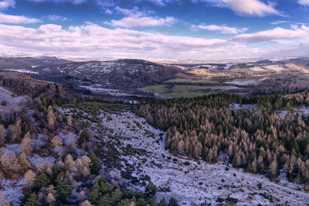
Taken right above the Highland Boundary Fault line looking north to the Sma’ Glen, Dallick House and plantation on the right and Roman Signal Station just visible as concentric rings in the bracken above a small burn.

Then comes the realization, due to geology, that the incredibly lumpy landscape is actually due to the Highland Boundary Fault running right through it – here, from left to right, along the line of the base of the hills and mountains. Lowlands beneath and behind, Highlands beyond to the north.

The second realization, due to heritage, is that the Romans had a series of “glen-blocker” forts along the Gask Ridge, of which one was situated here, at Fendoch. They even had a Signal Station across the road(!) – more accurately, across the fault line too – to alert the fort to incoming invasion from the north.

These days the fort itself is no great shakes – a few stone walls remaining and some faint outlines of rectangular structures beyond – and the Signal Station is a couple of concentric rings and a hint of more structure in the bracken.

Of course the final realization is thanks to the drone: rather that just the “intimate landscape” features within a few meters of one’s nose, one becomes aware of the landscape on a different scale of multiple miles and the way it’s divided up by roads and habitations (and how those have changed over the millenia).

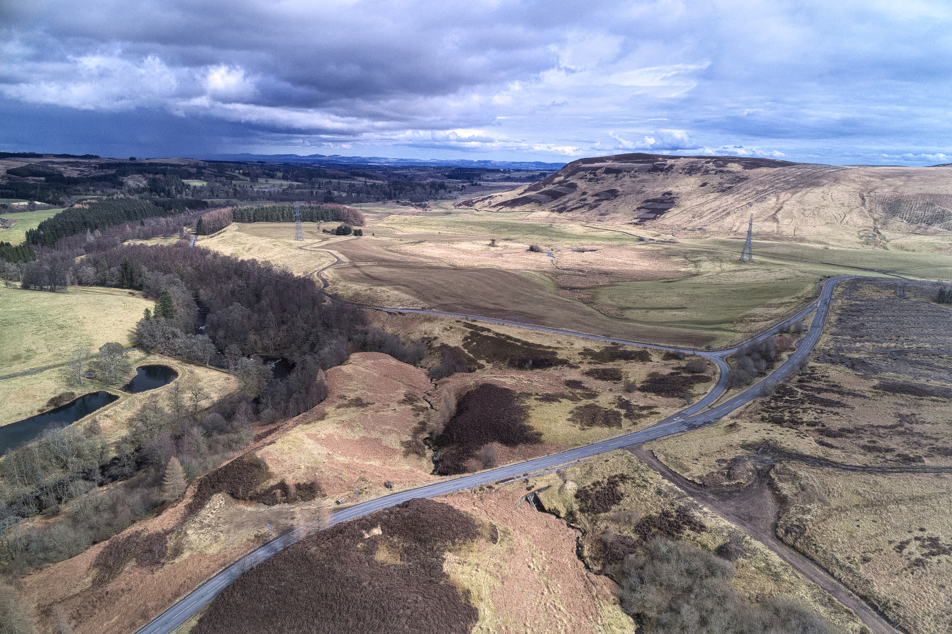
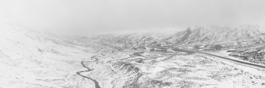
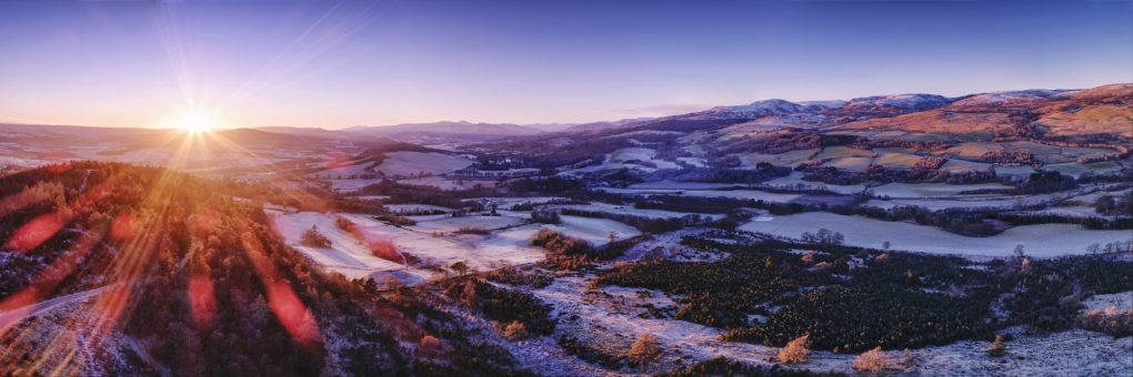
Roads slicing up the landscape: taken above the Roman Signal Station at the foot of the Sma’ Glen, looking south-east over the Highland Boundary Fault to Fendoch Roman Fort (between the pylons and Stroness hill in the distance) and thence along Glen Almond.

Going 3D: First Steps with Blender

Finally! It’s been only a dream for about 10 years but I have a new photo workflow – and one involving photogrammetry not just photography, too:

  • Fly a drone around an object – typically using point-of-interest mode whilst shooting video.
  • Run some structure-from-motion analysis using Open Drone Map
  • Import the resultant textured dense mesh into Blender
  • Play around with the scene, add lights and cameras…
  • Result!
Boarhills Church, East Neuk, Fife - 3D model rendered in Blender

Boarhills Church, East Neuk, Fife – 3D model rendered in Blender

OK, so it’s not quite as good as the native HDR off the drone but it will allow for even more flexibility in future artwork 🙂

Nature’s black and white

Just one photo – from Sunday afternoon, flying the drone along Glenshee just down the A93 from the ski centre at the Cairnwell.

Some years ago, Dad and I went up the Cairnwell and as we were at the top, watched a Hercules flying down the glen, below us, banking left at Spittal of Glenshee. Nice to be able to fly the area myself now!

Technicalities: 2 deg Celsius outisde, very low cloud base (easily within the drone’s permitted altitude but best avoided); an HDR panorama of 4 frames ISO 100, f/3.5, 1/400s (varying), processed in dcraw and stitched and finished in Serif Affinity Photo.

Above St Monan’s

The zig-zag harbour wall at St Monan’s is one of those iconic photographic locations where it’s impossible to pitch-up with tripod on top of the wall without being joined by multiple other photographers all seeking to perpetrate much the same cliché photo.

A much-shot photo, the zig-zag harbour wall at St Monan’s, Fife

Being stuck in Fife already, I called in at the village and sent the drone up to explore.

One of the first things I noticed is a tiny sign on one of the harbour wall ladders, warning the walk-way is closed. On aerial inspection, it’s possible to see the extent of damage it’s obviously suffered in the winter weather.

Winter weather erosion: the corner of the zig-zag dead-centre in the frame is obviously damaged

I was also very pleased to take a couple of new shots from the aerial perspective, straight down on the zig-zag – it shows how much the land-locked view compresses perspective. The water showed up a beautiful shade of green in the sunlight – and one can make out interference patterns of the waves and their reflections off the harbour wall:

I also nabbed a couple of views of the village, particular the Auld Kirk to the west and the view back across the harbour to the east.

Last Light, Stirling

Driving up the M90 past Stirling there is a little mound of a hillock at Craigforth, opposite Cambusbarron, which I thought might afford a nice view of the city at dusk.
In practice the mound is owned by a large insurance company with lots of restricted access by road, so I found Scout Head hill a couple of miles down the A811 near Gargunnock.
The snow was nearly a foot deep in parts so it took 1.5hr to walk 3 miles, uphill and down, to say nothing of 1.5hr making photos off the top.

The light was totally awesome. As expected, the hill’s shadow crept across the landscape, chasing the warm sunlight up the Wallace Monument and Stirling Castle, leaving Dumyat as the sky turned pink/purple/blue in the Earth’s Shadow.

I made a little timelapse video:


Beautiful winter landscape; the shadow moved its way across the landscape, with the last light making its way over the Wallace Monument and Stirling Castle before heading up Dumyat

I flew the drone away from the camera location and made an HDR panorama of Stirling from the air:

The last of the warm light – foreground partially cleared forestry in the shadow of Scout Head hill – contrasting with light on Craigforth, the Wallace Monument and Stirling Castle with Dumyat in the background.

Walking back down the hill in the cold twilight, the mountains of the Trossachs were glowing with white snow against the cobalt blue sky.

(I loved that light so much, I’ve made it available as a framed print via RedBubble already.)

The Forth is just a wee river this far west, but it still gave rise to a cloud of mist obscuring the view of local farms:

It’s only a wee river at this point, but the Forth gave off a large cloud of mist after dusk, obscuring the local farms.

And finishing up with the mankind-vs-nature theme, the Wallace Monument and orange streetlights of Stirling made a great contrast against the blue sky:

A mixture of lighting: vibrant orange tones of Stirling contrasting with the cobalt blue night sky above.

Above the Highland Boundary Fault

About 3-4 years ago, I first visited Birnam Hill. Made it around Duncan’s Hill to the south and through the woods… As I walked a path between old and new forestry, I wondered why there was a sharp drop down almost a metre to the level of the new trees.

Over subsequent visits I took a few photos, came back and took geotagged photos, all around the same area, went to the BGS, imported bedrock data via KML into Google Earth, correlated with the photos… After a couple of years I’m confident that the dip in the landscape is evidence of the Highland Boundary Fault – a line that runs all the way from Arran and Comrie to the south-west, through Stare Dam and Rohallion Loch and lodge, up along this dip between the trees and away to the east before heading off north-east to near Stonehaven. From a suitable angle it looks like someone’s taken a bicycle tyre and run it over the landscape, causing an impression relative to the surrounding hills and mountains.

Apart from that, the scene from Stair Bridge Viewpoint is highly photogenic and while I’ve made several photos of the view south and east since, I’ve always wanted to fly a drone along the line of the fault.

A few days ago, the dream came true: a perfect clear dry bright sunny winter’s day, snow lying on the ground, low sun illuminating the ground, all quiet and calm.

A clear winter’s day:

You have to be standing all-but on the HBF to take this:

A selfie, of sorts: straight down landing on Stair Bridge:

I managed a couple of runs from near Rohallion Lodge up toward the A9 with the drone, spliced them together into a fly-by to give an impression of the topology.

And a still photo (I still shoot them! – but mostly HDR panoramas…) looking east from above the cusp of the saddle landform between old and new forests:


To wrap up the afternoon, there was some lovely light on an avenue of beech trees, walking back to the main road:

Bucket-list Item: CHECKED!

Strathearn Sunset

My sense of the geography of Strathearn has not really fitted together until quite recently. There have been a few locations, isolated points and a few lines: the A822 from Gilmerton up past Monzie to the Sma’ Glen; The Hosh at the foot to access Glen Turret; a small B-road between the two; a hill known as Kate McNiven’s Crag; and one or two other areas. More recently I’ve been climbing hills, “bagging” Torlum Hill and Laggan Hill as part of the Lady Mary’s Walk circuit out of Crieff.

The Highland Boundary Fault emerges in a burst of very lumpy landscape at the southern end of the Sma’ Glen. But what it does in the rest of Strathearn to the west, I’ve never really seen.

A couple of weekends ago I explored the Knock of Crieff independently; it struck me that the path up the north side afforded the perfect view along the length of the strath to the far mountains in the west, an elevated view along the glacial U-shape.

So late on Sunday afternoon I took the drone for a spin slightly out over the strath and made a panorama of 7 shots, each a 5-shot HDR exposure bracket sequence – blended on Linux, stitched and edited in Serif Affinity Photo for the iPad.

Lowlands to the left of me; Highlands to the right…

And just for the record, this is what it looked like in the middle of stitched the blended panorama, before I cropped and toned it:

Panorama stitching screenshot

The Nice Place(TM)

It’s been a bit of a dream, a life-mission of a bucket-list item, but the other week I flew over some of the Caledonian Forest at Glen Affric – the drone’s maiden flight, as it happens, and a new way to admire the trees from a different angle.

A scene I hope to revisit more often as flying skills evolve.

Above Kinnoull Hill

I’ve discovered DJI GS (“groundstation”) Pro, which allows me to plot-out routes in advance with waypoints and control what happens at them, long before arriving at a location.

Well, currently we’re at the stage of wondering why the camera’s pointing back the way we came when it should be looking exactly the opposite direction.

Still, there’s a lot of nice views to be had above Kinnoull Hill.


And the finished video:

Around Binnend

After serendipitously discovering a lot of heritage information about the abandoned former village of Binnend, on The Binn outside Burntisland in Fife, I spent much of Sunday afternoon exploring the area.

It was smaller than I expected from the maps – about 30x30m or so – and very overgrown. The central region is a mix of thick gorse and fallen boulders, so not really accessible by foot. Use of the drone was hampered by several factors: being immediately adjacent to the Alcan landfill waste processing site, still an active commercial operation; by being a few hundred yards away from Craigkelly transmitter which caused significant radio interference (warnings in the DJI Go app and actual loss of video signal above a few meters’ altitude), so I did not get the fly-over video I’d intended.

Still. Herewith, a few still photos instead:

Approaching Binnend:

Within Binnend itself:

Above Binnend: