Caithness Holiday Day 2: Whaligoe Steps and Camster Cairns

Many moons ago… the parents and I were on holiday around Caithness and having trouble finding the way to Whaligoe Steps. As his tractor turned by the end of the field, we stopped a farmer to ask directions. To southern ears, the instructions sounded memorably like “turn right at the fussky-osk”. With a little thought we established the meaning… and twenty-two years later I still remember the turn of phrase and was pleased to identify the first phone-box in this Spring’s return visit.

Whaligoe Steps themselves are 365 steps down the side of a steep cliff to a former port for offloading herring boats; women would gut the fish and carry it up in barrels.

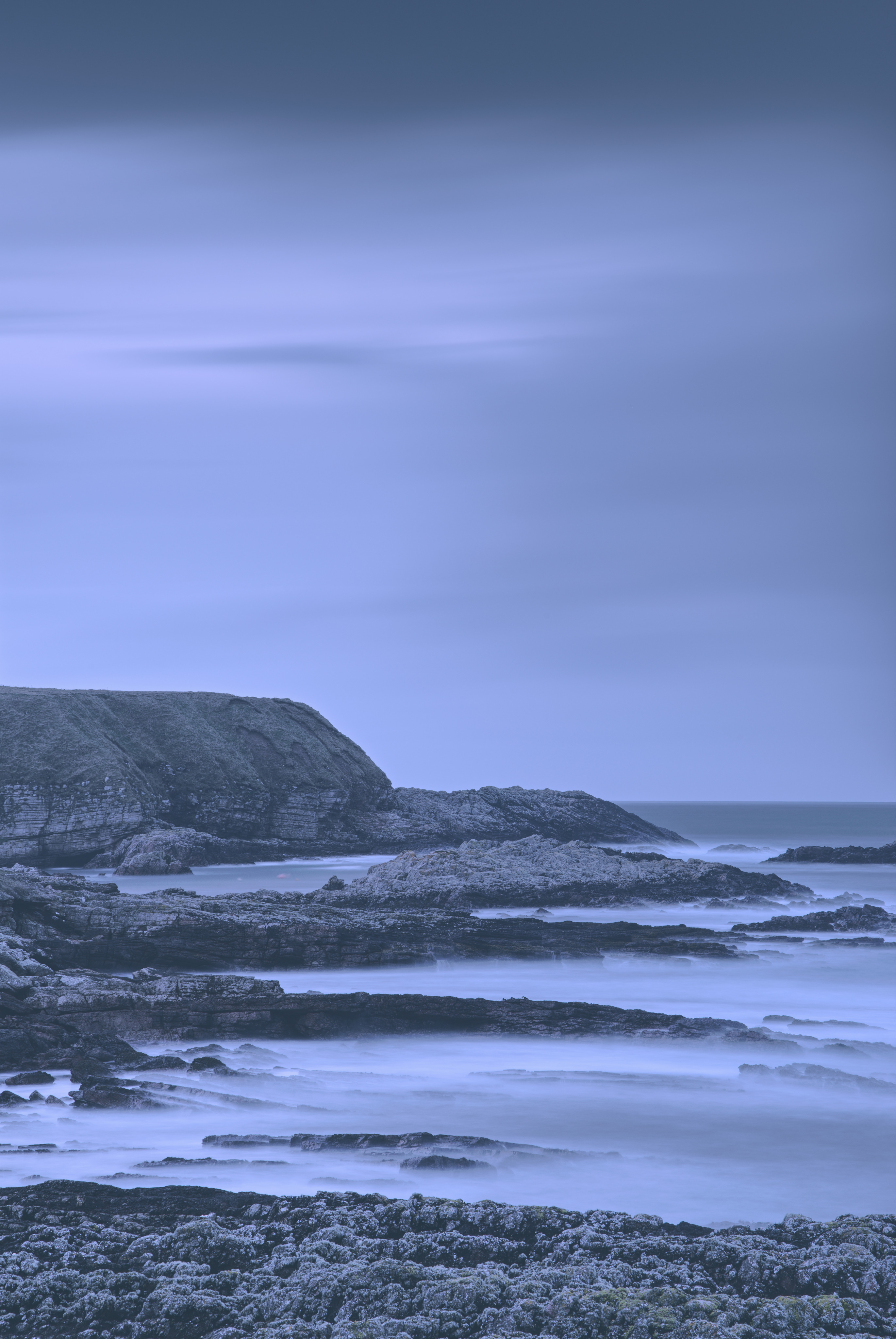
The place itself is quite an impressive geo with a fault nearby in the rock – strata lines pushed up by thrust – and pleasant views out to sea.

Further down the road are Camster Cairns – quite impressively large piles of rocks with interior chambers, perhaps the oldest buildings in Scotland at 5000yr old.

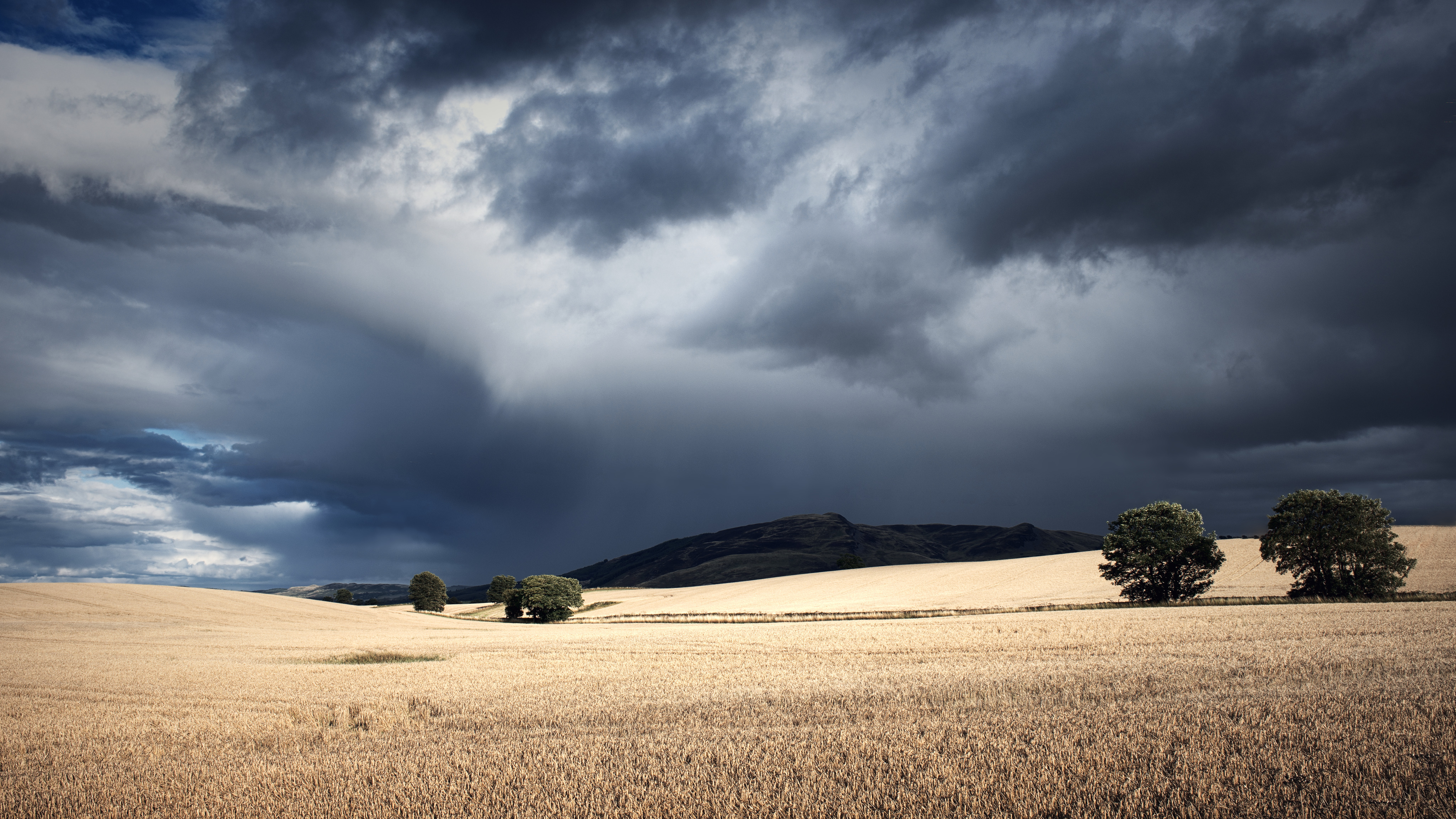
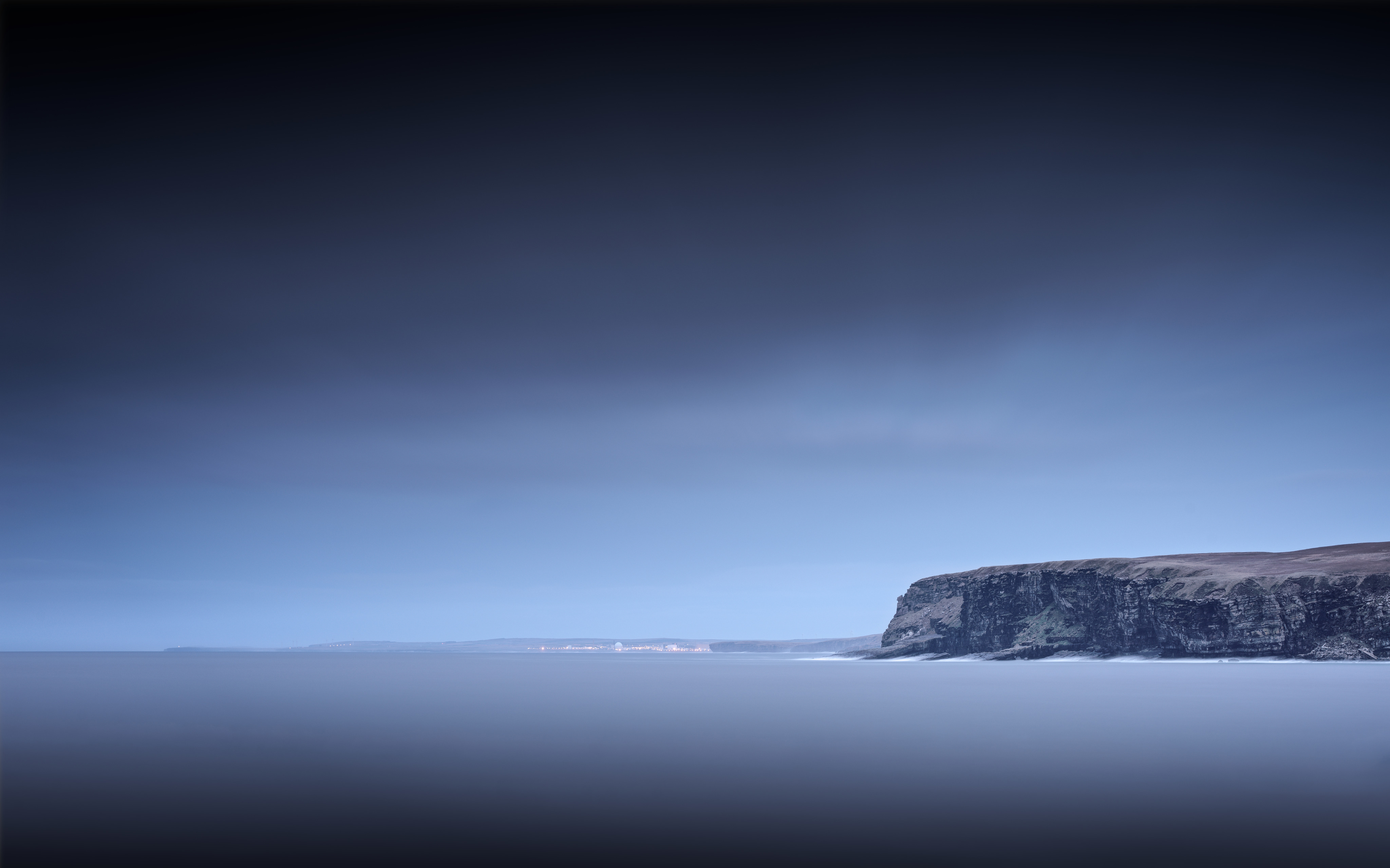
It had been another ludicrously hot day, with temperatures up over 25-28ºC, so we finished the day’s explorations on the north coast at the Slates of Fulligoe in East Mey, where the setting sun was partially obscured by a thick sea haar – very pleasantly cool.


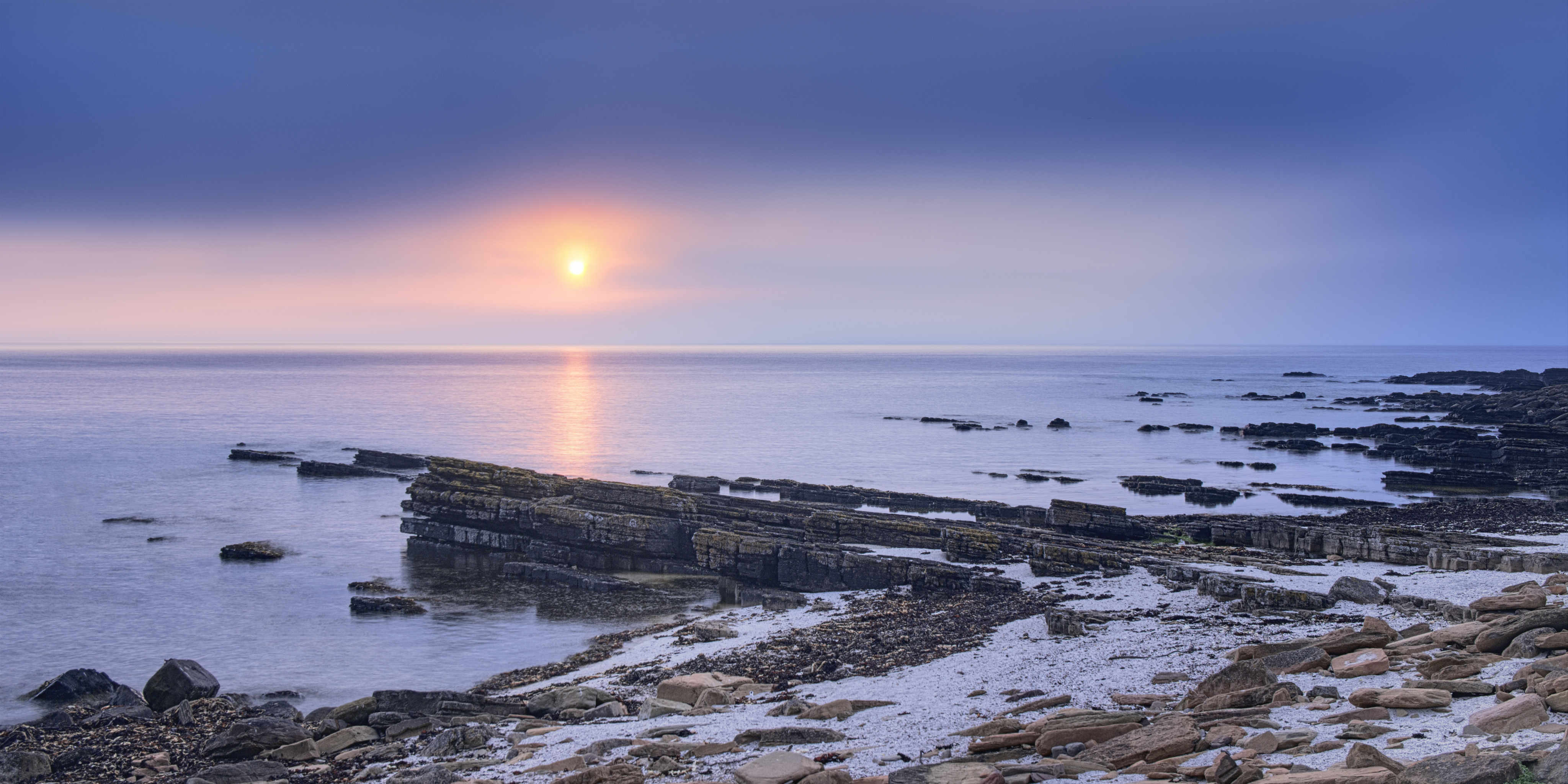
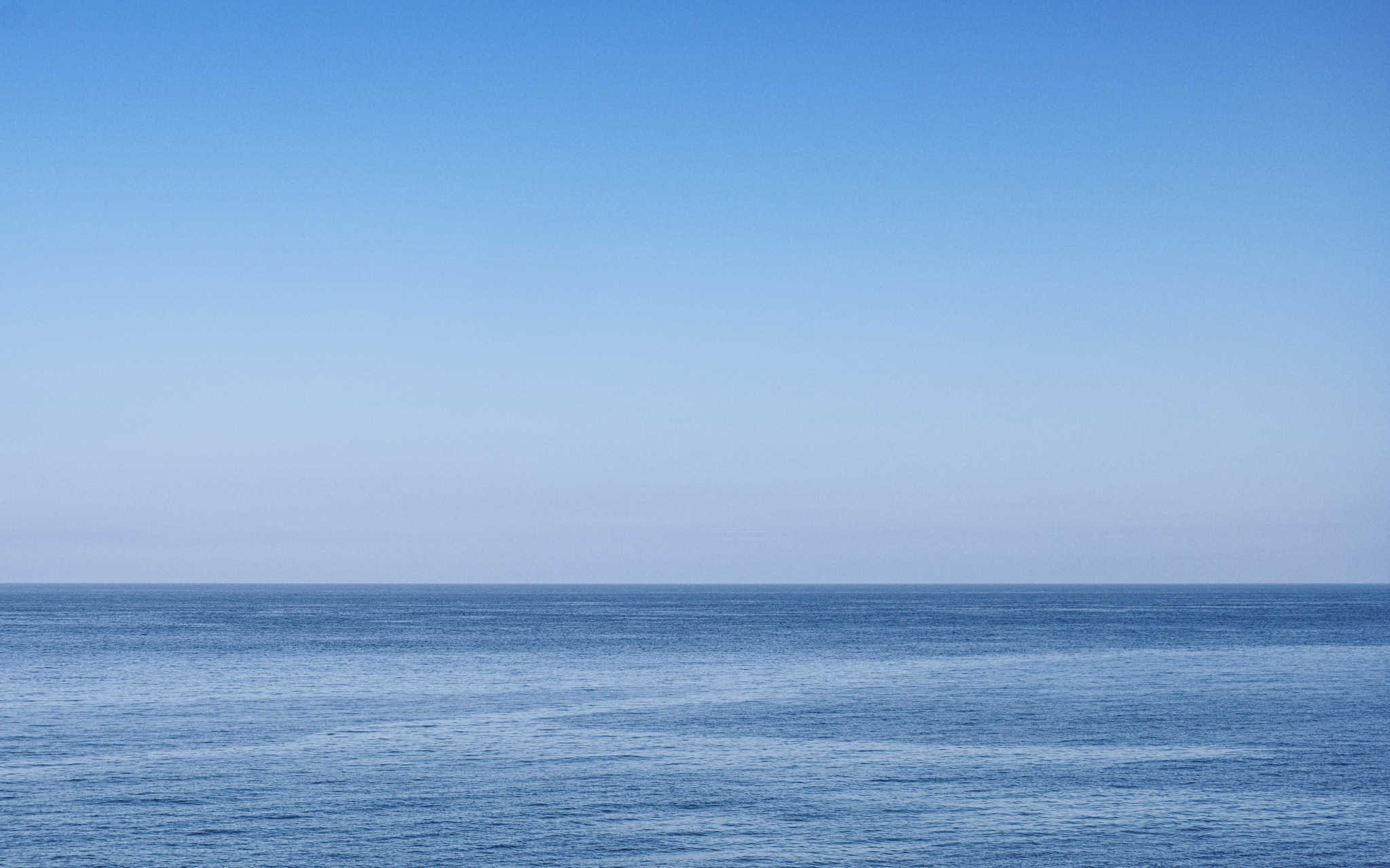
This was the second evening I’d set out to make a timelapse of the sunset into dusk. At least this time I was prepared for haar coming in off the sea (chose a safer less-cliff-top location near the path back, for starters). It did not disappoint: over the course of an hour the sun moved, the waves came and went, and a huge bank of fog moved in transforming the scene from brilliant sunset reflecting on the water, to complete white-out. All the possible moods of the landscape in barely an hour – quite awesome.
This photo is a temporal flattening of a timelapse sequence – using the intervalometer to shoot HDR brackets 3*±1EV at regular intervals which can be made either into a timelapse video or averaged-out into a still, like this. (The sun itself is blended from fewer images to avoid motion blur.)

A Bit Damp

Another Friday evening, another great way to end the week with a camera in hand. As I finished up work, wondering whether to mow the lawn, I looked out the window and saw awesome clouds zipping past.

Grab camera, grab Dog, go walkies and shoot whatever happens. There was rain. There was sun.

And after the rain, the sun illuminating the gently undulating crop fields contrasted amazingly with the remaining ominous clouds beyond.

Simple undulating rural countryside – with dramatic clouds above.

Exploring Strathearn

I spent a happy evening exploring the Quoig area in Strathearn – the floodplain of the river Earn between Comrie and Crieff, south of the A85. Disused railway line, Sir David Baird’s monument and a luscious sunset. Can’t complain 🙂


West Woods of Ethie

It was one of those crazy late-spring days with a clear divide in the weather – everywhere north of the highland boundary fault was meant to get extreme precipitation, while Fife and Angus remained cool and dry. So we walked for a while in the West Woods of Ethie, admiring the lines and shapes of tall beech trees and subtle light and shade under the canopy.

Aberdeenshire Coast: Catterline

I’d never really explored much of the Aberdeenshire coastline. On Saturday, however – feeling liberated from EV range anxiety – I discovered Catterline, just south of Fowlsheugh and Dunnottar. Towards the end of a beautiful sunny day, with just enough low golden light on the landscape… I had to fly the drone a bit, too.

The coast enjoys many large rocky outcrops (all conglomerate for a few miles around):

Perhaps my favourite shot is one of the more unusual by my standards: quite a thought-out composition of receding layers of rock, with the cliffs behind casting a huge shadow mid-way up one of the rocks, with Todhead Point lighthouse in the distance – near and far, light and dark, mankind and nature all rolled into one:

Todhead Point Lighthouse from Catterline Bay

Not bad going for the little Fuji camera; having set it to f/16 for depth of field, I’m surprised it chose exposures 1/52s and 1/26s at ISO 1600 and 1/60 at ISO 1000 for its HDR bracketing, but the results are excellent, no noise problems even in the shadows.

To finish, a simple statement of peace: nothing much, just sky above, a gentle disturbance in the sea below; all is calm, all is blue:

Peace: blue sky, blue sea

Birks of Aberfeldy

A few weeks ago, I spent a happy Saturday afternoon strolling around the Birks of Aberfeldy, testing the newly acquired Fuji X-T20.

For context, a general landscape of the lower end of the gorge with the Moness water flowing around rocks and pebbles in the riverbed:

The Moness river flowing over rocks and pebbles

For consistency, everything else was shot coupled with the Helios 58mm f/2 lens using the Acros+Yellow black&white film emulation mode and ISO 200.

Some abstract tree foliage patterns:

Details of tiny flowers closeup:

Of all the mini-waterfalls up the left side of the gorge, I’m particularly fond of the way the water flows over the moss on this one:

Statue of Robert Burns sitting on a bench:

Scultpure of Robert Burns sitting on a bench at the Birks of Aberfeldy

Shortly after these photos were made, the heavens opened – a huge cumulonimbus cloud the shape of the Starship Enterprise disgorged itself over a lot of Highland Perthshire, flooding the roads in Aberfeldy itself; as I was walking down the north side of the gorge, it was quite disconcerting feeling the sandy gravel getting washed away in the channels underfoot. Fun fun!

Twilight

Some more tests of the Fuji X-T20 in low light conditions.

Summer has the worst daytime light for photography with harsh shadows and washed-out pale tones; however I love the night sky with its permanent twilight (at this latitude) giving cobalt blue sky with hints of the sun’s warmth just below the horizon.

Plus it’s more comfortable than winter astrophotography 😉

Three studies in cloud structure – nature’s abstract patterns and a tiny blob of light of a hamlet across Strathearn:

Continuing the anthropocene-influence theme, glorious blue, red and pale clouds in an orange-tinged sky against a tiny pylon breaking the horizon:

The Pylon

The Pylon


Waterfalls and Mountains

We spent Saturday afternoon driving around the Tay Forest Park – up to the Mains of Taymouth at Kenmore for lunch then along the south Loch Tay road to the Falls of Acharn – a comparatively steep climb up the side of the gorge and negligible water in the falls, but there was pleasant subtle light making the most of the colours on the surrounding rocks:

Nice rocks (typical Highland semi-pelite) covered with colourful beech leaves and green moss. Shame they’d forgot to turn the water on…

Next stop: just outside Ardeonaig there is a tiny layby where the view of the southern end of Loch Tay opens up. There was pleasant light on the sides of Ben Lawers too:

Still a favoured viewpoint right by the side of the South Loch Tay road – lovely soft mountainside illuminated by gentle light and shadow.

Driving further down the road to Killin, there was an awesome cloud inversion flowing around Ben More in the distance, outside Crianlarich – so I stopped at Lix Toll services and made a panorama of it:

Observant viewers will spot there’s even a tiny fragment of snow remaining toward the far left of the shot on Stob Binnein – not bad for the last week of June!

The final stop of the afternoon was at Edinample Falls along the South Loch Earn road – a small gorge but beautifully shaped with pleasant light through the surrounding trees and a decent amount of water flowing around the rocks.

An overview of the waterfalls at Edinample – lovely sunlight illuminating the rocks nearby


Spittal of Glenshee

I don’t remember much about the hotel in Spittal of Glenshee – I suspect I saw it a few times when passing by up the glen, but that’s about it. I didn’t have recourse or time to visit the area for a few years, during which time it burned down in 2014 – quite a transformation, leaving the land just fenced-off to decay.

Nice setting:

As an aside, a friend and I were recently nattering about the saturation slider and how there’s always a temptation to overdo it. I mentioned that some images seem to “resonate” at multiple spots across the saturation axis – maybe fully saturated like slide film of old, maybe flatter like colour neg film of old, maybe artistically desaturated, maybe full-on black&white. The above image seems to work at 3 degrees.

Funky ruins:

Around Bangour

Situated outside Livingston, the psychiatric hospital at Bangour Village was founded in 1906 as Edinburgh District Asylum – one of the first in Scotland to be modelled on a village. In 1918 it housed up to 3000 patients. During the second World War, patients were transferred temporarily to Hartwoodhill Hospital. Around 1924-1930 it gained a multi-denominational church in the centre of the village.

These days the site consists of several listed buildings, most in increasing states of decay – ideal territory for urban exploration.

A few views from ground level:

And a handful of photos made with the drone:

Also see an aerial 360º drone panorama of Bangour I made using Hangar360.


The final ward closed in 2004 – worryingly one of those “in my lifetime” things…

Sma’ Glen: liminal landscape

Many years ago, as I was buying my first ever house in Perth, I remember the solicitor advocating the Sma’ Glen as a landscape to explore and photograph. He wasn’t wrong, but it’s taken over a decade to really start to explore it properly.

First there’s the natural appreciation of the place – light and landscape.

Taken right above the Highland Boundary Fault line looking north to the Sma’ Glen, Dallick House and plantation on the right and Roman Signal Station just visible as concentric rings in the bracken above a small burn.

Then comes the realization, due to geology, that the incredibly lumpy landscape is actually due to the Highland Boundary Fault running right through it – here, from left to right, along the line of the base of the hills and mountains. Lowlands beneath and behind, Highlands beyond to the north.

The second realization, due to heritage, is that the Romans had a series of “glen-blocker” forts along the Gask Ridge, of which one was situated here, at Fendoch. They even had a Signal Station across the road(!) – more accurately, across the fault line too – to alert the fort to incoming invasion from the north.

These days the fort itself is no great shakes – a few stone walls remaining and some faint outlines of rectangular structures beyond – and the Signal Station is a couple of concentric rings and a hint of more structure in the bracken.

Of course the final realization is thanks to the drone: rather that just the “intimate landscape” features within a few meters of one’s nose, one becomes aware of the landscape on a different scale of multiple miles and the way it’s divided up by roads and habitations (and how those have changed over the millenia).

Roads slicing up the landscape: taken above the Roman Signal Station at the foot of the Sma’ Glen, looking south-east over the Highland Boundary Fault to Fendoch Roman Fort (between the pylons and Stroness hill in the distance) and thence along Glen Almond.

The Far North

The intended road from Rosal due east was closed for road-works; I took an incredibly long detour all the way to the far north coast of Scotland – next stop the Faroes and Greenland – and stopped at Portskerra to make a couple of long exposure landscapes as the light faded to dusk.

The coastal geology was impressive – alternating areas of gneiss and sandstone with clear strata in the rock.

Portskerra at dusk – a long exposure of waves lapping around rocks on the beach looking north – next stop Greenland…

Dounreay in the distance beyond the next headland

Around Rosal

This was a strange place of varying thoughtfulness. Having previously visited Aoineadh Mor and found its handful of ruined crofts more thought-provoking, this was rather the opposite experience: having far more settlements dating back thousands of years including cairns, a souterrain and remains of crofts, with a history of particularly brutal evictions, there’s no real viewpoint from which one can see the extent of the clearing and experience all the time or place at once, so it lacks a certain atmosphere.

One thought, however. The Highland Clearances were mostly for the purposes of replacing crofting (seen as not cost-effective) with sheep farming (supposedly profitable). In practice, it’s a story about commercial failure: the sheep did not prove profitable, rendering the grassland barren; the monoculture spruce woodlands being farmed as the latest cash-crop are also barren, failing to nourish the land; the eviction of folks living a subsistence existence (which increasingly feels the innocent honest approach) was an offence against humanity – and yet the blasted sheep still remain.

The state of the Forestry Commission’s tourist information boards also being cast down on the ground, however, did provoke thought – is that sheer vandalism, an artistic statement about care and decay of property, or super-artistic irony that preservation itself should go the same way of all things?


The landscape did provide a few moments of beautiful contrast, illuminating the foreground trees against the shadowy dark might of Ben Loyal, however:

Ben Loyal from Rosal Clearance village

Ben Loyal from Rosal Clearance village

Around Strathnaver

Strathnaver is a beautiful area – rural life, peaceful and quiet, where the only traffic jam is a herd of sheep trundling along the road beside the loch. Simple and elemental, a play of sky and land, light and limited human influence.

Outside Altnaharra:

Beside Loch Naver: